


les couimes

guyzinz
User
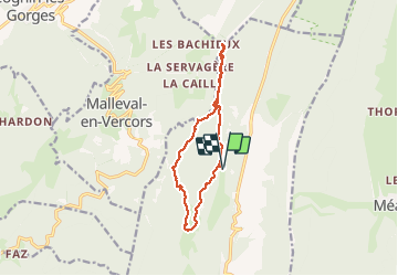

Length
11.6 km

Max alt
1440 m

Uphill gradient
450 m
Km-Effort
17.7 km

Min alt
1130 m

Downhill gradient
456 m
Boucle
Yes
Creation date :
2020-03-12 08:11:38.159
Updated on :
2020-03-12 13:43:40.07
5h24
Difficulty : Very easy

FREE GPS app for hiking
 SityTrail
IGN / Geographical institutes
SityTrail Plus
The world is yours!
About
Trail Walking of 11.6 km to be discovered at Auvergne-Rhône-Alpes, Isère, Rencurel. This trail is proposed by guyzinz.
Positioning
Country:
France
Region :
Auvergne-Rhône-Alpes
Department/Province :
Isère
Municipality :
Rencurel
Location:
Unknown
Start:(Dec)
Start:(UTM)
694304 ; 5000927 (31T) N.
Comments