


U2020 Bouzeron

clabidault
User
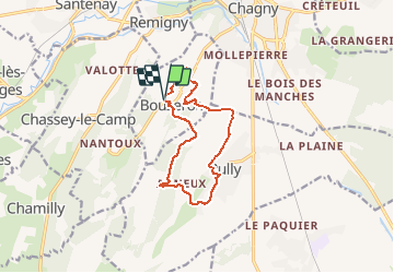

Length
11.3 km

Max alt
365 m

Uphill gradient
293 m
Km-Effort
15.2 km

Min alt
220 m

Downhill gradient
289 m
Boucle
Yes
Creation date :
2020-03-13 13:00:13.75
Updated on :
2020-04-20 19:12:57.248
3h36
Difficulty : Very easy

FREE GPS app for hiking
 SityTrail
IGN / Geographical institutes
SityTrail Plus
The world is yours!
About
Trail Walking of 11.3 km to be discovered at Bourgogne-Franche-Comté, Saône-et-Loire, Bouzeron. This trail is proposed by clabidault.
Positioning
Country:
France
Region :
Bourgogne-Franche-Comté
Department/Province :
Saône-et-Loire
Municipality :
Bouzeron
Location:
Unknown
Start:(Dec)
Start:(UTM)
631368 ; 5194458 (31T) N.
Comments