


Le Bois d'Agnat, Chazeron.

Gegetop
User

Length
8.9 km

Max alt
705 m

Uphill gradient
185 m
Km-Effort
11.3 km

Min alt
604 m

Downhill gradient
186 m
Boucle
Yes
Creation date :
2020-03-14 10:19:44.713
Updated on :
2020-03-14 15:14:03.625
2h19
Difficulty : Easy
2h00
Difficulty : Easy

FREE GPS app for hiking
 SityTrail
IGN / Geographical institutes
SityTrail Plus
The world is yours!
About
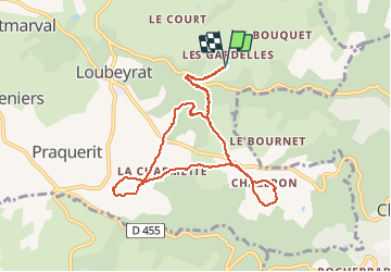
Trail Walking of 8.9 km to be discovered at Auvergne-Rhône-Alpes, Puy-de-Dôme, Loubeyrat. This trail is proposed by Gegetop.
Description
Boucle Aller et retour par Le Colombier
Photos

Positioning
Country:
France
Region :
Auvergne-Rhône-Alpes
Department/Province :
Puy-de-Dôme
Municipality :
Loubeyrat
Location:
Unknown
Start:(Dec)
Start:(UTM)
502253 ; 5086984 (31T) N.
Comments