


Sauveplantade 6km

thonyc
User GUIDE
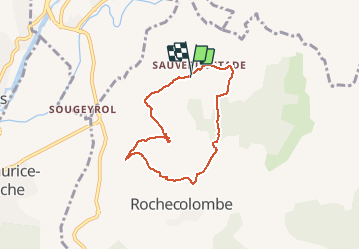

Length
6 km

Max alt
278 m

Uphill gradient
114 m
Km-Effort
7.5 km

Min alt
184 m

Downhill gradient
114 m
Boucle
Yes
Creation date :
2020-03-14 15:58:56.886
Updated on :
2020-03-14 16:06:15.167
1h37
Difficulty : Easy

FREE GPS app for hiking
 SityTrail
IGN / Geographical institutes
SityTrail Plus
The world is yours!
About
Trail Walking of 6 km to be discovered at Auvergne-Rhône-Alpes, Ardèche, Rochecolombe. This trail is proposed by thonyc.
Positioning
Country:
France
Region :
Auvergne-Rhône-Alpes
Department/Province :
Ardèche
Municipality :
Rochecolombe
Location:
Unknown
Start:(Dec)
Start:(UTM)
613954 ; 4932231 (31T) N.
Comments