


fontaines 15 mars 2020

Tollard
User
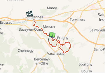

Length
23 km

Max alt
270 m

Uphill gradient
447 m
Km-Effort
29 km

Min alt
149 m

Downhill gradient
534 m
Boucle
No
Creation date :
2020-03-15 08:51:48.404
Updated on :
2020-03-15 11:07:43.59
2h15
Difficulty : Medium

FREE GPS app for hiking
 SityTrail
IGN / Geographical institutes
SityTrail Plus
The world is yours!
About
Trail Mountain bike of 23 km to be discovered at Grand Est, Aube, Bucey-en-Othe. This trail is proposed by Tollard.
Positioning
Country:
France
Region :
Grand Est
Department/Province :
Aube
Municipality :
Bucey-en-Othe
Location:
Unknown
Start:(Dec)
Start:(UTM)
567342 ; 5343424 (31U) N.
Comments