


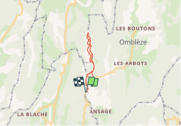
Canyon des Gueulards / 8.4 km / 365 m +

okfred26
User

Length
8.4 km

Max alt
830 m

Uphill gradient
365 m
Km-Effort
13.3 km

Min alt
580 m

Downhill gradient
365 m
Boucle
Yes
Creation date :
2020-03-15 16:49:37.158
Updated on :
2020-03-15 16:57:10.357
2h44
Difficulty : Difficult

FREE GPS app for hiking
 SityTrail
IGN / Geographical institutes
SityTrail Plus
The world is yours!
About
Trail Walking of 8.4 km to be discovered at Auvergne-Rhône-Alpes, Drôme, Plan-de-Baix. This trail is proposed by okfred26.
Positioning
Country:
France
Region :
Auvergne-Rhône-Alpes
Department/Province :
Drôme
Municipality :
Plan-de-Baix
Location:
Unknown
Start:(Dec)
Start:(UTM)
672935 ; 4967316 (31T) N.
Comments