


Marolles

werth
User
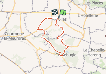

Length
11.4 km

Max alt
173 m

Uphill gradient
211 m
Km-Effort
14.3 km

Min alt
88 m

Downhill gradient
210 m
Boucle
Yes
Creation date :
2020-03-15 14:38:19.144
Updated on :
2020-03-15 17:44:01.365
3h04
Difficulty : Very easy

FREE GPS app for hiking
 SityTrail
IGN / Geographical institutes
SityTrail Plus
The world is yours!
About
Trail Walking of 11.4 km to be discovered at Normandy, Calvados, Marolles. This trail is proposed by werth.
Description
très jolie. à éviter après la pluie. boueux.
Positioning
Country:
France
Region :
Normandy
Department/Province :
Calvados
Municipality :
Marolles
Location:
Unknown
Start:(Dec)
Start:(UTM)
308370 ; 5446220 (31U) N.
Comments