


Saillans

raygautier
User
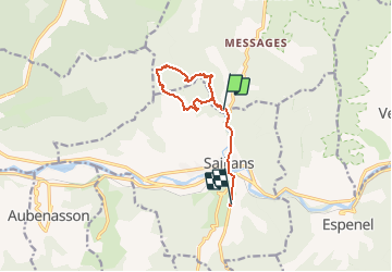

Length
9.5 km

Max alt
559 m

Uphill gradient
327 m
Km-Effort
13.9 km

Min alt
257 m

Downhill gradient
344 m
Boucle
No
Creation date :
2020-03-15 14:30:24.0
Updated on :
2020-03-17 16:50:42.162
18h47
Difficulty : Unknown

FREE GPS app for hiking
 SityTrail
IGN / Geographical institutes
SityTrail Plus
The world is yours!
About
Trail Walking of 9.5 km to be discovered at Auvergne-Rhône-Alpes, Drôme, Véronne. This trail is proposed by raygautier.
Description
Visite des marmites et direction Col de pourcheton et retour au village
Positioning
Country:
France
Region :
Auvergne-Rhône-Alpes
Department/Province :
Drôme
Municipality :
Véronne
Location:
Unknown
Start:(Dec)
Start:(UTM)
673900 ; 4953032 (31T) N.
Comments