


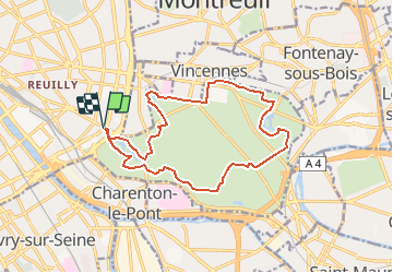
Tour du bois de Vincennes

c.chehere
User

Length
15.1 km

Max alt
66 m

Uphill gradient
117 m
Km-Effort
16.7 km

Min alt
40 m

Downhill gradient
115 m
Boucle
Yes
Creation date :
2020-03-22 16:23:57.673
Updated on :
2020-03-24 17:23:42.544
3h42
Difficulty : Difficult

FREE GPS app for hiking
 SityTrail
IGN / Geographical institutes
SityTrail Plus
The world is yours!
About
Trail Walking of 15.1 km to be discovered at Ile-de-France, Paris, Paris. This trail is proposed by c.chehere.
Description
Début de la rando porte dorée accessible par le tram T3.
Retour même endroit
Positioning
Country:
France
Region :
Ile-de-France
Department/Province :
Paris
Municipality :
Paris
Location:
12th Arrondissement
Start:(Dec)
Start:(UTM)
456446 ; 5409328 (31U) N.
Comments