


Confinement ok’ Je à

alinetpierre
User
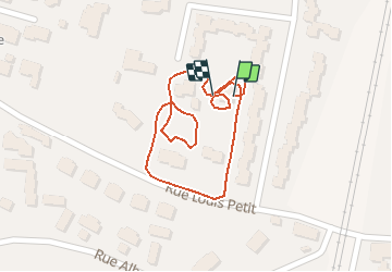

Length
500 m

Max alt
162 m

Uphill gradient
1 m
Km-Effort
513 m

Min alt
160 m

Downhill gradient
1 m
Boucle
Yes
Creation date :
2020-03-22 16:51:12.0
Updated on :
2020-03-22 17:00:33.57
7m
Difficulty : Unknown

FREE GPS app for hiking
 SityTrail
IGN / Geographical institutes
SityTrail Plus
The world is yours!
About
Trail Walking of 500 m to be discovered at Auvergne-Rhône-Alpes, Drôme, Romans-sur-Isère. This trail is proposed by alinetpierre.
Positioning
Country:
France
Region :
Auvergne-Rhône-Alpes
Department/Province :
Drôme
Municipality :
Romans-sur-Isère
Location:
Unknown
Start:(Dec)
Start:(UTM)
659937 ; 4989552 (31T) N.
Comments