


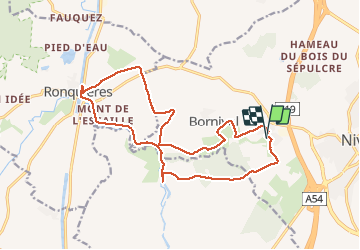
boucle ronquiere

tometaurelia
User

Length
16.3 km

Max alt
130 m

Uphill gradient
217 m
Km-Effort
19.2 km

Min alt
55 m

Downhill gradient
218 m
Boucle
Yes
Creation date :
2020-03-22 12:18:13.143
Updated on :
2020-03-23 12:56:42.756
3h09
Difficulty : Very easy

FREE GPS app for hiking
 SityTrail
IGN / Geographical institutes
SityTrail Plus
The world is yours!
About
Trail Walking of 16.3 km to be discovered at Wallonia, Walloon Brabant, Nivelles. This trail is proposed by tometaurelia.
Positioning
Country:
Belgium
Region :
Wallonia
Department/Province :
Walloon Brabant
Municipality :
Nivelles
Location:
Monstreux
Start:(Dec)
Start:(UTM)
591190 ; 5605951 (31U) N.
Comments