


2020-04-03_16h53m10_Circuit Mons en Pévèle- Variante courte

dehemjacques
User
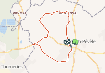

Length
7.2 km

Max alt
94 m

Uphill gradient
92 m
Km-Effort
8.4 km

Min alt
46 m

Downhill gradient
89 m
Boucle
Yes
Creation date :
2020-04-03 14:53:10.777
Updated on :
2020-04-03 15:05:02.142
2h30
Difficulty : Easy

FREE GPS app for hiking
 SityTrail
IGN / Geographical institutes
SityTrail Plus
The world is yours!
About
Trail On foot of 7.2 km to be discovered at Hauts-de-France, Nord, Mons-en-Pévèle. This trail is proposed by dehemjacques.
Description
Départ de l'Office de Tourisme de Mons en Pévèle
Prudence le long de la départementale du Lieu dit "les deux villes" à l'entrée de la voie verte
Positioning
Country:
France
Region :
Hauts-de-France
Department/Province :
Nord
Municipality :
Mons-en-Pévèle
Location:
Unknown
Start:(Dec)
Start:(UTM)
507207 ; 5591930 (31U) N.
Comments