


2020-04-04_21h15m27_Naninne-2014-03-04

sarriette
User
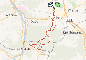

Length
13.6 km

Max alt
280 m

Uphill gradient
316 m
Km-Effort
17.8 km

Min alt
131 m

Downhill gradient
316 m
Boucle
Yes
Creation date :
2020-04-04 19:15:30.178
Updated on :
2020-04-04 21:20:28.057
--
Difficulty : Very easy

FREE GPS app for hiking
 SityTrail
IGN / Geographical institutes
SityTrail Plus
The world is yours!
About
Trail On foot of 13.6 km to be discovered at Wallonia, Namur, Namur. This trail is proposed by sarriette.
Positioning
Country:
Belgium
Region :
Wallonia
Department/Province :
Namur
Municipality :
Namur
Location:
Naninne
Start:(Dec)
Start:(UTM)
636769 ; 5587752 (31U) N.
Comments