


De Thomery à Fontainebleau

jpcccb
User
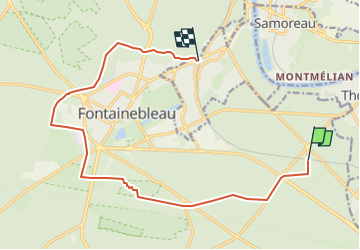

Length
14.2 km

Max alt
132 m

Uphill gradient
182 m
Km-Effort
16.7 km

Min alt
78 m

Downhill gradient
193 m
Boucle
No
Creation date :
2020-04-07 12:55:55.634
Updated on :
2023-04-29 11:37:33.064
3h47
Difficulty : Easy

FREE GPS app for hiking
 SityTrail
IGN / Geographical institutes
SityTrail Plus
The world is yours!
About
Trail On foot of 14.2 km to be discovered at Ile-de-France, Seine-et-Marne, Fontainebleau. This trail is proposed by jpcccb.
Positioning
Country:
France
Region :
Ile-de-France
Department/Province :
Seine-et-Marne
Municipality :
Fontainebleau
Location:
Unknown
Start:(Dec)
Start:(UTM)
482529 ; 5360151 (31U) N.
Comments