


*Forêt de Marly (de Marly le Roi à St Nom la Bretèche).

jpcccb
User
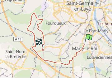

Length
13.8 km

Max alt
192 m

Uphill gradient
296 m
Km-Effort
17.7 km

Min alt
108 m

Downhill gradient
272 m
Boucle
No
Creation date :
2020-04-08 15:26:11.028
Updated on :
2023-05-09 14:30:34.274
--
Difficulty : Very easy

FREE GPS app for hiking
 SityTrail
IGN / Geographical institutes
SityTrail Plus
The world is yours!
About
Trail On foot of 13.8 km to be discovered at Ile-de-France, Yvelines, Marly-le-Roi. This trail is proposed by jpcccb.
Positioning
Country:
France
Region :
Ile-de-France
Department/Province :
Yvelines
Municipality :
Marly-le-Roi
Location:
Unknown
Start:(Dec)
Start:(UTM)
433743 ; 5413540 (31U) N.
Comments