


de Nanteuil Saacy à la Ferté sous Jouarre

jpcccb
User
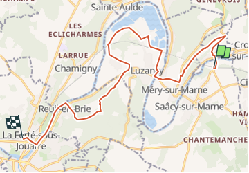

Length
16.5 km

Max alt
172 m

Uphill gradient
284 m
Km-Effort
20 km

Min alt
49 m

Downhill gradient
284 m
Boucle
No
Creation date :
2020-04-09 09:16:19.177
Updated on :
2023-05-13 13:58:11.725
4h37
Difficulty : Medium

FREE GPS app for hiking
 SityTrail
IGN / Geographical institutes
SityTrail Plus
The world is yours!
About
Trail On foot of 16.5 km to be discovered at Ile-de-France, Seine-et-Marne, Saâcy-sur-Marne. This trail is proposed by jpcccb.
Positioning
Country:
France
Region :
Ile-de-France
Department/Province :
Seine-et-Marne
Municipality :
Saâcy-sur-Marne
Location:
Unknown
Start:(Dec)
Start:(UTM)
516123 ; 5424571 (31U) N.
Comments