


de molliéres cavaillac au col de mouzoulés

pipette12
User
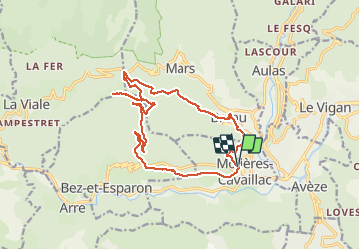

Length
17.7 km

Max alt
835 m

Uphill gradient
730 m
Km-Effort
27 km

Min alt
291 m

Downhill gradient
727 m
Boucle
Yes
Creation date :
2014-12-10 00:00:00.0
Updated on :
2014-12-10 00:00:00.0
5h47
Difficulty : Difficult

FREE GPS app for hiking
 SityTrail
IGN / Geographical institutes
SityTrail Plus
The world is yours!
About
Trail Walking of 17.7 km to be discovered at Occitania, Gard, Molières-Cavaillac. This trail is proposed by pipette12.
Description
le départ s'effectue au parking du cimetiére de moliéres cavaillacen direction de bréau et salagosse le col de mouzoulés esparon et retour au point de départ par les magnifiques rochers d'esparon
Positioning
Country:
France
Region :
Occitania
Department/Province :
Gard
Municipality :
Molières-Cavaillac
Location:
Unknown
Start:(Dec)
Start:(UTM)
546182 ; 4869421 (31T) N.
Comments