


de Igny à Massy

jpcccb
User
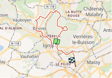

Length
14.4 km

Max alt
184 m

Uphill gradient
258 m
Km-Effort
17.8 km

Min alt
58 m

Downhill gradient
249 m
Boucle
No
Creation date :
2020-04-11 12:42:31.348
Updated on :
2024-10-07 14:04:25.728
4h02
Difficulty : Easy

FREE GPS app for hiking
 SityTrail
IGN / Geographical institutes
SityTrail Plus
The world is yours!
About
Trail On foot of 14.4 km to be discovered at Ile-de-France, Essonne, Igny. This trail is proposed by jpcccb.
Positioning
Country:
France
Region :
Ile-de-France
Department/Province :
Essonne
Municipality :
Igny
Location:
Unknown
Start:(Dec)
Start:(UTM)
443473 ; 5398852 (31U) N.
Comments