


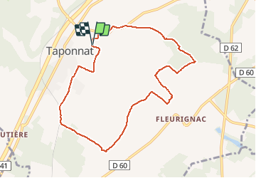
De Taponnat à Fleurignac

alainjoseph6
User

Length
9.3 km

Max alt
136 m

Uphill gradient
110 m
Km-Effort
10.8 km

Min alt
96 m

Downhill gradient
110 m
Boucle
Yes
Creation date :
2015-05-01 00:00:00.0
Updated on :
2019-02-03 19:10:01.603
2h26
Difficulty : Unknown

FREE GPS app for hiking
 SityTrail
IGN / Geographical institutes
SityTrail Plus
The world is yours!
About
Trail Walking of 9.3 km to be discovered at New Aquitaine, Charente, Taponnat-Fleurignac. This trail is proposed by alainjoseph6.
Description
Randonnée très facile peut être réalisée en famille.
Photos


Positioning
Country:
France
Region :
New Aquitaine
Department/Province :
Charente
Municipality :
Taponnat-Fleurignac
Location:
Unknown
Start:(Dec)
Start:(UTM)
299107 ; 5072844 (31T) N.
Comments