


Langeac - Lavoûte Chilhac

DaVinci
User
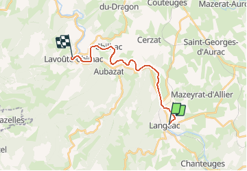

Length
16.5 km

Max alt
503 m

Uphill gradient
145 m
Km-Effort
18.5 km

Min alt
458 m

Downhill gradient
178 m
Boucle
No
Creation date :
2020-04-13 14:13:25.189
Updated on :
2020-04-18 09:18:47.318
2h45
Difficulty : Medium

FREE GPS app for hiking
 SityTrail
IGN / Geographical institutes
SityTrail Plus
The world is yours!
About
Trail Canoe - kayak of 16.5 km to be discovered at Auvergne-Rhône-Alpes, Haute-Loire, Langeac. This trail is proposed by DaVinci.
Positioning
Country:
France
Region :
Auvergne-Rhône-Alpes
Department/Province :
Haute-Loire
Municipality :
Langeac
Location:
Unknown
Start:(Dec)
Start:(UTM)
539234 ; 4994266 (31T) N.
Comments