


de Villennes sur Seine à Poissy

jpcccb
User
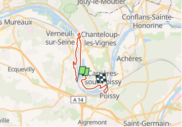

Length
17.2 km

Max alt
56 m

Uphill gradient
158 m
Km-Effort
19.3 km

Min alt
14 m

Downhill gradient
158 m
Boucle
No
Creation date :
2020-04-14 15:12:58.616
Updated on :
2023-05-05 14:59:29.817
4h23
Difficulty : Easy

FREE GPS app for hiking
 SityTrail
IGN / Geographical institutes
SityTrail Plus
The world is yours!
About
Trail On foot of 17.2 km to be discovered at Ile-de-France, Yvelines, Villennes-sur-Seine. This trail is proposed by jpcccb.
Positioning
Country:
France
Region :
Ile-de-France
Department/Province :
Yvelines
Municipality :
Villennes-sur-Seine
Location:
Unknown
Start:(Dec)
Start:(UTM)
426715 ; 5421208 (31U) N.
Comments