


Projet As - 15 nov. 2020

pierlan
User
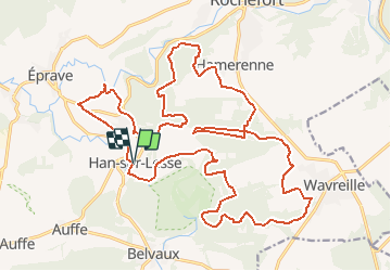

Length
27 km

Max alt
326 m

Uphill gradient
689 m
Km-Effort
36 km

Min alt
149 m

Downhill gradient
689 m
Boucle
Yes
Creation date :
2020-04-17 12:37:12.766
Updated on :
2020-04-17 14:41:29.579
5h00
Difficulty : Very easy

FREE GPS app for hiking
 SityTrail
IGN / Geographical institutes
SityTrail Plus
The world is yours!
About
Trail Trail of 27 km to be discovered at Wallonia, Namur, Rochefort. This trail is proposed by pierlan.
Positioning
Country:
Belgium
Region :
Wallonia
Department/Province :
Namur
Municipality :
Rochefort
Location:
Han-sur-Lesse
Start:(Dec)
Start:(UTM)
656365 ; 5554858 (31U) N.
Comments