


2020-04-19_18h44m00_Ronquerolles

avdem
User
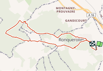

Length
10.2 km

Max alt
187 m

Uphill gradient
211 m
Km-Effort
13 km

Min alt
71 m

Downhill gradient
216 m
Boucle
Yes
Creation date :
2020-04-19 16:44:02.418
Updated on :
2020-04-19 16:44:05.529

FREE GPS app for hiking
 SityTrail
IGN / Geographical institutes
SityTrail Plus
The world is yours!
About
Trail of 10.2 km to be discovered at Ile-de-France, Val-d'Oise, Ronquerolles. This trail is proposed by avdem.
Positioning
Country:
France
Region :
Ile-de-France
Department/Province :
Val-d'Oise
Municipality :
Ronquerolles
Location:
Unknown
Start:(Dec)
Start:(UTM)
443213 ; 5446302 (31U) N.
Comments