


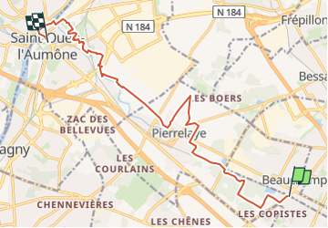
De Montigny Beauchamp à Saint Ouen l'Aumône

jpcccb
User

Length
14.2 km

Max alt
68 m

Uphill gradient
82 m
Km-Effort
15.4 km

Min alt
18 m

Downhill gradient
116 m
Boucle
No
Creation date :
2020-04-23 14:14:47.474
Updated on :
2023-04-27 14:27:07.26
3h29
Difficulty : Easy

FREE GPS app for hiking
 SityTrail
IGN / Geographical institutes
SityTrail Plus
The world is yours!
About
Trail On foot of 14.2 km to be discovered at Ile-de-France, Val-d'Oise, Montigny-lès-Cormeilles. This trail is proposed by jpcccb.
Description
Montigny les Cormeilles, Pierrelaye, chaussée de César , les Vacheries, Ru de Liesse, Parc et Abbaye de Maubuisson, bords de l'Oise.
Positioning
Country:
France
Region :
Ile-de-France
Department/Province :
Val-d'Oise
Municipality :
Montigny-lès-Cormeilles
Location:
Unknown
Start:(Dec)
Start:(UTM)
441303 ; 5428585 (31U) N.
Comments