


Haut-le-Wastia Mai 1949 percee point de vue G

pjjrevrard
User
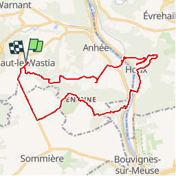

Length
17.2 km

Max alt
242 m

Uphill gradient
408 m
Km-Effort
23 km

Min alt
86 m

Downhill gradient
408 m
Boucle
Yes
Creation date :
2014-12-10 00:00:00.0
Updated on :
2014-12-10 00:00:00.0
4h27
Difficulty : Medium

FREE GPS app for hiking
 SityTrail
IGN / Geographical institutes
SityTrail Plus
The world is yours!
About
Trail Walking of 17.2 km to be discovered at Wallonia, Namur, Anhée. This trail is proposed by pjjrevrard.
Points of interest


Positioning
Country:
Belgium
Region :
Wallonia
Department/Province :
Namur
Municipality :
Anhée
Location:
Haut-le-Wastia
Start:(Dec)
Start:(UTM)
631234 ; 5574257 (31U) N.
Comments