


meuse . bernalmont . fond des tawes . citadelle . bueren . impasse ursulines

stef789
User GUIDE
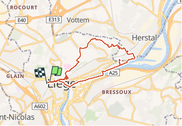

Length
14.4 km

Max alt
164 m

Uphill gradient
247 m
Km-Effort
17.7 km

Min alt
56 m

Downhill gradient
241 m
Boucle
Yes
Creation date :
2020-04-25 12:56:06.463
Updated on :
2020-04-25 16:41:32.3
3h04
Difficulty : Very easy

FREE GPS app for hiking
 SityTrail
IGN / Geographical institutes
SityTrail Plus
The world is yours!
About
Trail Walking of 14.4 km to be discovered at Wallonia, Liège, Liège. This trail is proposed by stef789.
Positioning
Country:
Belgium
Region :
Wallonia
Department/Province :
Liège
Municipality :
Liège
Location:
Glain
Start:(Dec)
Start:(UTM)
681394 ; 5613555 (31U) N.
Comments