


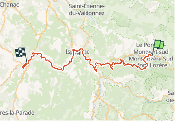
07 GTMC Le Pont de Montvert-Sainte Enimie

nicolas54230
User

Length
66 km

Max alt
1109 m

Uphill gradient
1465 m
Km-Effort
86 km

Min alt
464 m

Downhill gradient
1873 m
Boucle
No
Creation date :
2020-04-27 10:26:54.24
Updated on :
2020-05-03 20:51:59.887
29m
Difficulty : Easy

FREE GPS app for hiking
 SityTrail
IGN / Geographical institutes
SityTrail Plus
The world is yours!
About
Trail Mountain bike of 66 km to be discovered at Occitania, Lozère, Pont de Montvert - Sud Mont Lozère. This trail is proposed by nicolas54230.
Positioning
Country:
France
Region :
Occitania
Department/Province :
Lozère
Municipality :
Pont de Montvert - Sud Mont Lozère
Location:
Le Pont-de-Montvert
Start:(Dec)
Start:(UTM)
559534 ; 4912325 (31T) N.
Comments