


*De Rambouillet au Perray en Yveline

jpcccb
User
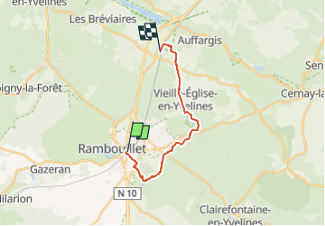

Length
14.2 km

Max alt
184 m

Uphill gradient
116 m
Km-Effort
15.7 km

Min alt
158 m

Downhill gradient
101 m
Boucle
No
Creation date :
2020-04-27 14:22:07.815
Updated on :
2023-05-09 13:25:17.903
--
Difficulty : Very easy

FREE GPS app for hiking
 SityTrail
IGN / Geographical institutes
SityTrail Plus
The world is yours!
About
Trail On foot of 14.2 km to be discovered at Ile-de-France, Yvelines, Rambouillet. This trail is proposed by jpcccb.
Description
Bois des Eveuses, Etang d'Or, GR 1, Etang de la Tour, sentier de l'aqueduc de la vieille église, Etang du Perray.
Positioning
Country:
France
Region :
Ile-de-France
Department/Province :
Yvelines
Municipality :
Rambouillet
Location:
Unknown
Start:(Dec)
Start:(UTM)
413896 ; 5388489 (31U) N.
Comments