


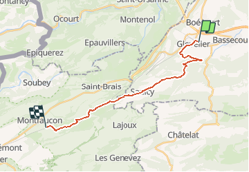
Glovelier - Joilmon - Pré Petitjean

bffcuc
User

Length
18.8 km

Max alt
999 m

Uphill gradient
743 m
Km-Effort
27 km

Min alt
504 m

Downhill gradient
319 m
Boucle
No
Creation date :
2014-12-11 00:00:00.0
Updated on :
2014-12-11 00:00:00.0
6h17
Difficulty : Unknown

FREE GPS app for hiking
 SityTrail
IGN / Geographical institutes
SityTrail Plus
The world is yours!
About
Trail Other activity of 18.8 km to be discovered at Jura, District de Delémont, Haute-Sorne. This trail is proposed by bffcuc.
Positioning
Country:
Switzerland
Region :
Jura
Department/Province :
District de Delémont
Municipality :
Haute-Sorne
Location:
Unknown
Start:(Dec)
Start:(UTM)
364719 ; 5243955 (32T) N.
Comments