


VAUVERT 200429

Dupuybadonniere
User
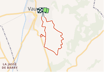

Length
6.1 km

Max alt
76 m

Uphill gradient
65 m
Km-Effort
6.9 km

Min alt
44 m

Downhill gradient
57 m
Boucle
Yes
Creation date :
2020-04-29 15:34:44.862
Updated on :
2020-04-29 16:39:14.822
1h04
Difficulty : Very easy

FREE GPS app for hiking
 SityTrail
IGN / Geographical institutes
SityTrail Plus
The world is yours!
About
Trail Walking of 6.1 km to be discovered at Occitania, Gard, Vauvert. This trail is proposed by Dupuybadonniere.
Positioning
Country:
France
Region :
Occitania
Department/Province :
Gard
Municipality :
Vauvert
Location:
Unknown
Start:(Dec)
Start:(UTM)
603061 ; 4838110 (31T) N.
Comments