


reco mouss 27 12 13

mouss65
User
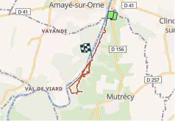

Length
5.7 km

Max alt
66 m

Uphill gradient
138 m
Km-Effort
7.6 km

Min alt
10 m

Downhill gradient
139 m
Boucle
No
Creation date :
2014-12-10 00:00:00.0
Updated on :
2014-12-10 00:00:00.0
1h59
Difficulty : Very easy

FREE GPS app for hiking
 SityTrail
IGN / Geographical institutes
SityTrail Plus
The world is yours!
About
Trail Running of 5.7 km to be discovered at Normandy, Calvados, Mutrécy. This trail is proposed by mouss65.
Positioning
Country:
France
Region :
Normandy
Department/Province :
Calvados
Municipality :
Mutrécy
Location:
Unknown
Start:(Dec)
Start:(UTM)
687951 ; 5439589 (30U) N.
Comments