


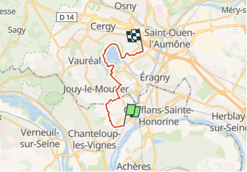
*De Maurecourt à Cergy Pontoise

jpcccb
User

Length
13.1 km

Max alt
104 m

Uphill gradient
164 m
Km-Effort
15.3 km

Min alt
17 m

Downhill gradient
166 m
Boucle
No
Creation date :
2020-05-02 14:36:01.857
Updated on :
2024-04-27 10:02:56.06
3h29
Difficulty : Easy

FREE GPS app for hiking
 SityTrail
IGN / Geographical institutes
SityTrail Plus
The world is yours!
About
Trail On foot of 13.1 km to be discovered at Ile-de-France, Yvelines, Andrésy. This trail is proposed by jpcccb.
Description
Maurecourt , bords de l'Oise, île des loisirs de Cergy, Port de plaisance, Cergy le vieux. 13 kms, modérée, reconnue.
Positioning
Country:
France
Region :
Ile-de-France
Department/Province :
Yvelines
Municipality :
Andrésy
Location:
Unknown
Start:(Dec)
Start:(UTM)
431204 ; 5426461 (31U) N.
Comments