


tour essey

randolea
User

Length
5.1 km

Max alt
232 m

Uphill gradient
37 m
Km-Effort
5.6 km

Min alt
213 m

Downhill gradient
37 m
Boucle
Yes
Creation date :
2020-05-03 11:46:53.467
Updated on :
2020-05-03 13:05:21.884
1h18
Difficulty : Very easy

FREE GPS app for hiking
 SityTrail
IGN / Geographical institutes
SityTrail Plus
The world is yours!
About
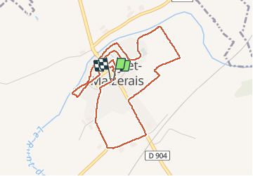
Trail Walking of 5.1 km to be discovered at Grand Est, Meurthe-et-Moselle, Essey-et-Maizerais. This trail is proposed by randolea.
Positioning
Country:
France
Region :
Grand Est
Department/Province :
Meurthe-et-Moselle
Municipality :
Essey-et-Maizerais
Location:
Unknown
Start:(Dec)
Start:(UTM)
705958 ; 5422164 (31U) N.
Comments