


Thy-le-Bauduin

Tahir
User
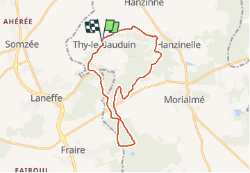

Length
13.2 km

Max alt
281 m

Uphill gradient
197 m
Km-Effort
15.8 km

Min alt
192 m

Downhill gradient
199 m
Boucle
Yes
Creation date :
2020-05-03 13:19:45.403
Updated on :
2020-05-03 14:55:20.364
1h35
Difficulty : Very easy

FREE GPS app for hiking
 SityTrail
IGN / Geographical institutes
SityTrail Plus
The world is yours!
About
Trail Running of 13.2 km to be discovered at Wallonia, Namur, Florennes. This trail is proposed by Tahir.
Positioning
Country:
Belgium
Region :
Wallonia
Department/Province :
Namur
Municipality :
Florennes
Location:
Thy-le-Bauduin
Start:(Dec)
Start:(UTM)
608486 ; 5572622 (31U) N.
Comments