


les cogne tons le 29 04 20

BertrandHubert
User
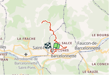

Length
12.5 km

Max alt
1602 m

Uphill gradient
478 m
Km-Effort
18.9 km

Min alt
1126 m

Downhill gradient
477 m
Boucle
Yes
Creation date :
2020-04-29 12:10:47.712
Updated on :
2020-05-03 14:56:24.251
2h46
Difficulty : Very easy

FREE GPS app for hiking
 SityTrail
IGN / Geographical institutes
SityTrail Plus
The world is yours!
About
Trail Walking of 12.5 km to be discovered at Provence-Alpes-Côte d'Azur, Alpes-de-Haute-Provence, Barcelonnette. This trail is proposed by BertrandHubert.
Positioning
Country:
France
Region :
Provence-Alpes-Côte d'Azur
Department/Province :
Alpes-de-Haute-Provence
Municipality :
Barcelonnette
Location:
Unknown
Start:(Dec)
Start:(UTM)
311942 ; 4917756 (32T) N.
Comments