


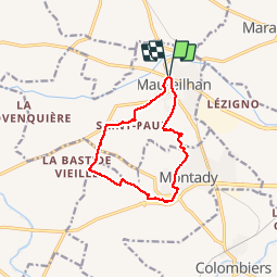
la maureilhanaise

Daron34
User

Length
11.6 km

Max alt
71 m

Uphill gradient
115 m
Km-Effort
13.1 km

Min alt
27 m

Downhill gradient
116 m
Boucle
Yes
Creation date :
2014-12-10 00:00:00.0
Updated on :
2014-12-10 00:00:00.0
2h38
Difficulty : Very easy

FREE GPS app for hiking
 SityTrail
IGN / Geographical institutes
SityTrail Plus
The world is yours!
About
Trail Walking of 11.6 km to be discovered at Occitania, Hérault, Maureilhan. This trail is proposed by Daron34.
Description
boucle maureilhan montady


Positioning
Country:
France
Region :
Occitania
Department/Province :
Hérault
Municipality :
Maureilhan
Location:
Unknown
Start:(Dec)
Start:(UTM)
509669 ; 4800624 (31T) N.
Comments