


Vélo rando sid St Cahors montée douce sur plateau

fxhedon
User
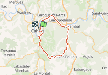

Length
25 km

Max alt
275 m

Uphill gradient
310 m
Km-Effort
30 km

Min alt
112 m

Downhill gradient
310 m
Boucle
Yes
Creation date :
2020-05-10 12:07:28.0
Updated on :
2020-05-10 14:57:53.523
2h49
Difficulty : Unknown

FREE GPS app for hiking
 SityTrail
IGN / Geographical institutes
SityTrail Plus
The world is yours!
About
Trail Mountain bike of 25 km to be discovered at Occitania, Lot, Cahors. This trail is proposed by fxhedon.
Description
Montée sur asphalte , assistance juste sur la fin . Bon exercice cardio
Positioning
Country:
France
Region :
Occitania
Department/Province :
Lot
Municipality :
Cahors
Location:
Unknown
Start:(Dec)
Start:(UTM)
375934 ; 4922939 (31T) N.
Comments