


mont aiguille monument

brandy
User
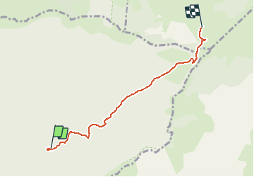

Length
5 km

Max alt
1620 m

Uphill gradient
674 m
Km-Effort
12 km

Min alt
1007 m

Downhill gradient
84 m
Boucle
No
Creation date :
2020-05-12 06:42:31.514
Updated on :
2020-05-12 07:02:15.977
2h39
Difficulty : Medium

FREE GPS app for hiking
 SityTrail
IGN / Geographical institutes
SityTrail Plus
The world is yours!
About
Trail Walking of 5 km to be discovered at Auvergne-Rhône-Alpes, Drôme, Romeyer. This trail is proposed by brandy.
Positioning
Country:
France
Region :
Auvergne-Rhône-Alpes
Department/Province :
Drôme
Municipality :
Romeyer
Location:
Unknown
Start:(Dec)
Start:(UTM)
693433 ; 4964317 (31T) N.
Comments