


Jouy + grand tour de Nesles

avdem
User
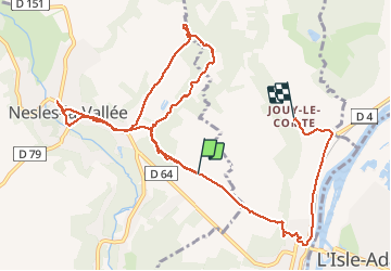

Length
11.6 km

Max alt
105 m

Uphill gradient
140 m
Km-Effort
13.6 km

Min alt
27 m

Downhill gradient
178 m
Boucle
No
Creation date :
2020-05-12 07:48:02.526
Updated on :
2020-05-12 10:50:25.626
3h01
Difficulty : Very easy

FREE GPS app for hiking
 SityTrail
IGN / Geographical institutes
SityTrail Plus
The world is yours!
About
Trail Walking of 11.6 km to be discovered at Ile-de-France, Val-d'Oise, Nesles-la-Vallée. This trail is proposed by avdem.
Description
tres bien et facile
Positioning
Country:
France
Region :
Ile-de-France
Department/Province :
Val-d'Oise
Municipality :
Nesles-la-Vallée
Location:
Unknown
Start:(Dec)
Start:(UTM)
441046 ; 5441264 (31U) N.
Comments