


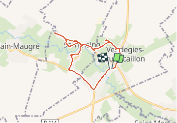
vendegies sur Ecaillon

BrassensJC
User

Length
6.3 km

Max alt
77 m

Uphill gradient
73 m
Km-Effort
7.3 km

Min alt
43 m

Downhill gradient
77 m
Boucle
Yes
Creation date :
2020-05-12 13:48:11.134
Updated on :
2020-05-12 15:31:38.3
1h42
Difficulty : Easy

FREE GPS app for hiking
 SityTrail
IGN / Geographical institutes
SityTrail Plus
The world is yours!
About
Trail Walking of 6.3 km to be discovered at Hauts-de-France, Nord, Vendegies-sur-Écaillon. This trail is proposed by BrassensJC.
Positioning
Country:
France
Region :
Hauts-de-France
Department/Province :
Nord
Municipality :
Vendegies-sur-Écaillon
Location:
Unknown
Start:(Dec)
Start:(UTM)
536376 ; 5567819 (31U) N.
Comments