


Crussol

raygautier
User
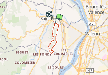

Length
8.2 km

Max alt
389 m

Uphill gradient
277 m
Km-Effort
12.1 km

Min alt
166 m

Downhill gradient
325 m
Boucle
No
Creation date :
2020-05-11 13:22:08.0
Updated on :
2020-05-12 21:22:37.915
2h25
Difficulty : Unknown

FREE GPS app for hiking
 SityTrail
IGN / Geographical institutes
SityTrail Plus
The world is yours!
About
Trail Walking of 8.2 km to be discovered at Auvergne-Rhône-Alpes, Ardèche, Saint-Péray. This trail is proposed by raygautier.
Positioning
Country:
France
Region :
Auvergne-Rhône-Alpes
Department/Province :
Ardèche
Municipality :
Saint-Péray
Location:
Unknown
Start:(Dec)
Start:(UTM)
645833 ; 4978078 (31T) N.
Comments