


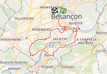
Besancon Forts Beure 12 mai 2020 Christian B

TRIMAILLE
User

Length
20 km

Max alt
463 m

Uphill gradient
859 m
Km-Effort
32 km

Min alt
231 m

Downhill gradient
858 m
Boucle
Yes
Creation date :
2020-05-13 13:42:17.926
Updated on :
2020-05-13 13:50:29.582
6h34
Difficulty : Difficult

FREE GPS app for hiking
 SityTrail
IGN / Geographical institutes
SityTrail Plus
The world is yours!
About
Trail Walking of 20 km to be discovered at Bourgogne-Franche-Comté, Doubs, Besançon. This trail is proposed by TRIMAILLE.
Description
Départ du Parking Canot. Longer le Doubs jusqu'a la voie cyclable. La suivre jusqu'aux escaliers. Les prendre et suivre le sentier jusqu'au fort de Chaudanne.
Positioning
Country:
France
Region :
Bourgogne-Franche-Comté
Department/Province :
Doubs
Municipality :
Besançon
Location:
Unknown
Start:(Dec)
Start:(UTM)
274174 ; 5235822 (32T) N.
Comments