


randonnee-a5389a7a6c87c1ff79d46a3e01dbaef7

MichelRando7656
User

Length
10.5 km

Max alt
175 m

Uphill gradient
141 m
Km-Effort
12.4 km

Min alt
88 m

Downhill gradient
141 m
Boucle
Yes
Creation date :
2020-05-14 08:19:18.119
Updated on :
2020-05-14 08:24:38.403
2h42
Difficulty : Medium

FREE GPS app for hiking
 SityTrail
IGN / Geographical institutes
SityTrail Plus
The world is yours!
About
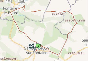
Trail Walking of 10.5 km to be discovered at Normandy, Seine-Maritime, Saint-Georges-sur-Fontaine. This trail is proposed by MichelRando7656.
Description
Départ de l’église de Saint-Georges sur Fontaine .
5ens horaire.
randonnee-a5389a7a6c87c1ff79d46a3e01dbaef7
Positioning
Country:
France
Region :
Normandy
Department/Province :
Seine-Maritime
Municipality :
Saint-Georges-sur-Fontaine
Location:
Unknown
Start:(Dec)
Start:(UTM)
368288 ; 5489512 (31U) N.
Comments