pic girantes ou mont ceint

vincentpascal31
User
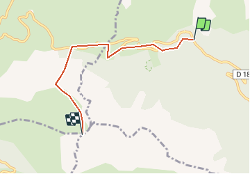

Length
5 km

Max alt
2060 m

Uphill gradient
876 m
Km-Effort
14 km

Min alt
1229 m

Downhill gradient
67 m
Boucle
No
Creation date :
2014-12-10 00:00:00.0
Updated on :
2020-02-19 21:51:19.714
3h09
Difficulty : Medium

FREE GPS app for hiking
 SityTrail
IGN / Geographical institutes
SityTrail Plus
The world is yours!
About
Trail Walking of 5 km to be discovered at Occitania, Ariège, Val-de-Sos. This trail is proposed by vincentpascal31.
Positioning
Country:
France
Region :
Occitania
Department/Province :
Ariège
Municipality :
Val-de-Sos
Location:
Suc-et-Sentenac
Start:(Dec)
Start:(UTM)
371963 ; 4740588 (31T) N.
Comments