


essais1

vasyjp
User

Length
13.7 km

Max alt
369 m

Uphill gradient
110 m
Km-Effort
15.6 km

Min alt
209 m

Downhill gradient
241 m
Boucle
No
Creation date :
2014-12-10 00:00:00.0
Updated on :
2014-12-10 00:00:00.0
7m
Difficulty : Unknown

FREE GPS app for hiking
 SityTrail
IGN / Geographical institutes
SityTrail Plus
The world is yours!
About
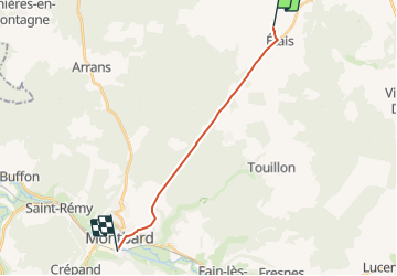
Trail Other activity of 13.7 km to be discovered at Bourgogne-Franche-Comté, Côte-d'Or, Étais. This trail is proposed by vasyjp.
Positioning
Country:
France
Region :
Bourgogne-Franche-Comté
Department/Province :
Côte-d'Or
Municipality :
Étais
Location:
Unknown
Start:(Dec)
Start:(UTM)
607534 ; 5285486 (31T) N.
Comments