


clermont ferrand Cebazat Durtol

jeanic63
User
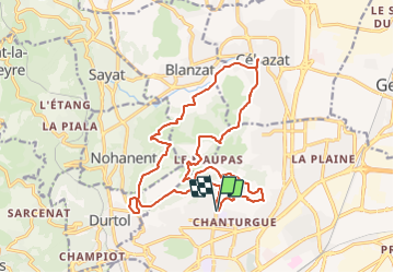

Length
21 km

Max alt
618 m

Uphill gradient
697 m
Km-Effort
30 km

Min alt
350 m

Downhill gradient
699 m
Boucle
Yes
Creation date :
2020-05-17 06:22:44.32
Updated on :
2021-12-12 16:26:24.237
--
Difficulty : Medium

FREE GPS app for hiking
 SityTrail
IGN / Geographical institutes
SityTrail Plus
The world is yours!
About
Trail On foot of 21 km to be discovered at Auvergne-Rhône-Alpes, Puy-de-Dôme, Clermont-Ferrand. This trail is proposed by jeanic63.
Description
départ clermont ferrant angle rue de blanzat rue des sagotiers
Positioning
Country:
France
Region :
Auvergne-Rhône-Alpes
Department/Province :
Puy-de-Dôme
Municipality :
Clermont-Ferrand
Location:
Unknown
Start:(Dec)
Start:(UTM)
506666 ; 5071519 (31T) N.
Comments