


seine

DaVinci
User
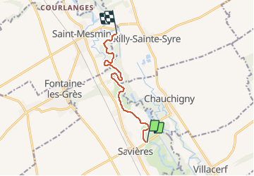

Length
7.3 km

Max alt
90 m

Uphill gradient
34 m
Km-Effort
7.8 km

Min alt
82 m

Downhill gradient
34 m
Boucle
No
Creation date :
2020-05-17 07:34:48.356
Updated on :
2020-05-17 11:17:00.179
1h36
Difficulty : Very easy

FREE GPS app for hiking
 SityTrail
IGN / Geographical institutes
SityTrail Plus
The world is yours!
About
Trail Canoe - kayak of 7.3 km to be discovered at Grand Est, Aube, Savières. This trail is proposed by DaVinci.
Positioning
Country:
France
Region :
Grand Est
Department/Province :
Aube
Municipality :
Savières
Location:
Unknown
Start:(Dec)
Start:(UTM)
570867 ; 5362314 (31U) N.
Comments