


17.05.2020 - Saint Martin

delm
User
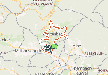

Length
12.2 km

Max alt
514 m

Uphill gradient
406 m
Km-Effort
17.7 km

Min alt
284 m

Downhill gradient
420 m
Boucle
Yes
Creation date :
2020-05-17 09:10:24.0
Updated on :
2020-05-18 15:38:14.411
3h56
Difficulty : Easy

FREE GPS app for hiking
 SityTrail
IGN / Geographical institutes
SityTrail Plus
The world is yours!
About
Trail Walking of 12.2 km to be discovered at Grand Est, Bas-Rhin, Saint-Martin. This trail is proposed by delm.
Description
agréable randonnée variée entre prairie et forêt
Positioning
Country:
France
Region :
Grand Est
Department/Province :
Bas-Rhin
Municipality :
Saint-Martin
Location:
Unknown
Start:(Dec)
Start:(UTM)
373208 ; 5356730 (32U) N.
Comments
Super rando