


fagnes d'Odeigne

Chanchan63
User
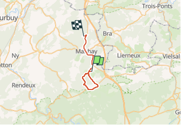

Length
23 km

Max alt
644 m

Uphill gradient
372 m
Km-Effort
28 km

Min alt
439 m

Downhill gradient
447 m
Boucle
No
Creation date :
2020-05-17 10:49:21.213
Updated on :
2022-07-21 10:31:16.876
4h12
Difficulty : Very easy

FREE GPS app for hiking
 SityTrail
IGN / Geographical institutes
SityTrail Plus
The world is yours!
About
Trail Walking of 23 km to be discovered at Wallonia, Luxembourg, Manhay. This trail is proposed by Chanchan63.
Positioning
Country:
Belgium
Region :
Wallonia
Department/Province :
Luxembourg
Municipality :
Manhay
Location:
Unknown
Start:(Dec)
Start:(UTM)
691867 ; 5570636 (31U) N.
Comments