


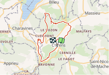
Autour de Chirens - 17 mai 2020

morganee
User

Length
15.9 km

Max alt
811 m

Uphill gradient
487 m
Km-Effort
22 km

Min alt
454 m

Downhill gradient
488 m
Boucle
Yes
Creation date :
2020-05-17 08:41:37.097
Updated on :
2020-05-17 15:12:17.339
4h03
Difficulty : Medium

FREE GPS app for hiking
 SityTrail
IGN / Geographical institutes
SityTrail Plus
The world is yours!
About
Trail Walking of 15.9 km to be discovered at Auvergne-Rhône-Alpes, Isère, Chirens. This trail is proposed by morganee.
Description
boucle autour de Chirens par la tour de Clermont, la Croix des cochettes, la Guilletière et le marais
Positioning
Country:
France
Region :
Auvergne-Rhône-Alpes
Department/Province :
Isère
Municipality :
Chirens
Location:
Unknown
Start:(Dec)
Start:(UTM)
699936 ; 5031921 (31T) N.
Comments